

Decisions. Admittedly, we at The Backwards Van are not great with them. So if someone else wants to make them for us, a local person, a complete stranger, an online review, a dream I had or even fate itself, that is absolutely fine by us. Somewhere along the winding backroads between Falkirk and the Trossachs National Park, someone (fate I assume, it was definitey not a dream) put a glossy brochure in our hands and that was that, decisions of what direction we were taking next were made based entirely upon that publication. We are quite easily influenced these days, we know, but why not, and now Dixie was going island hopping!
Island hopping, in Scotland? Much to our surprise too, we found there are plenty of ferry routes available that cover all the sets of the Western Isles. As usual, the farthest away we can go is the place we want to go, and the group of islands that interested us most were the Outer Hebrides.
Most people associate island hopping with the warm turquoise waters of the Carribbean, cocktails at sunset, the sounds of steel drums in the warm breeze. What we found, all the way out west on those rocky outcrops in the sea was way more Caribbean than we could ever have imagined, not in a tropical, drinking rum from a coconut kind of way, a distinctly Celtic and uniquely Scottish-Irish kind of Caribbean.
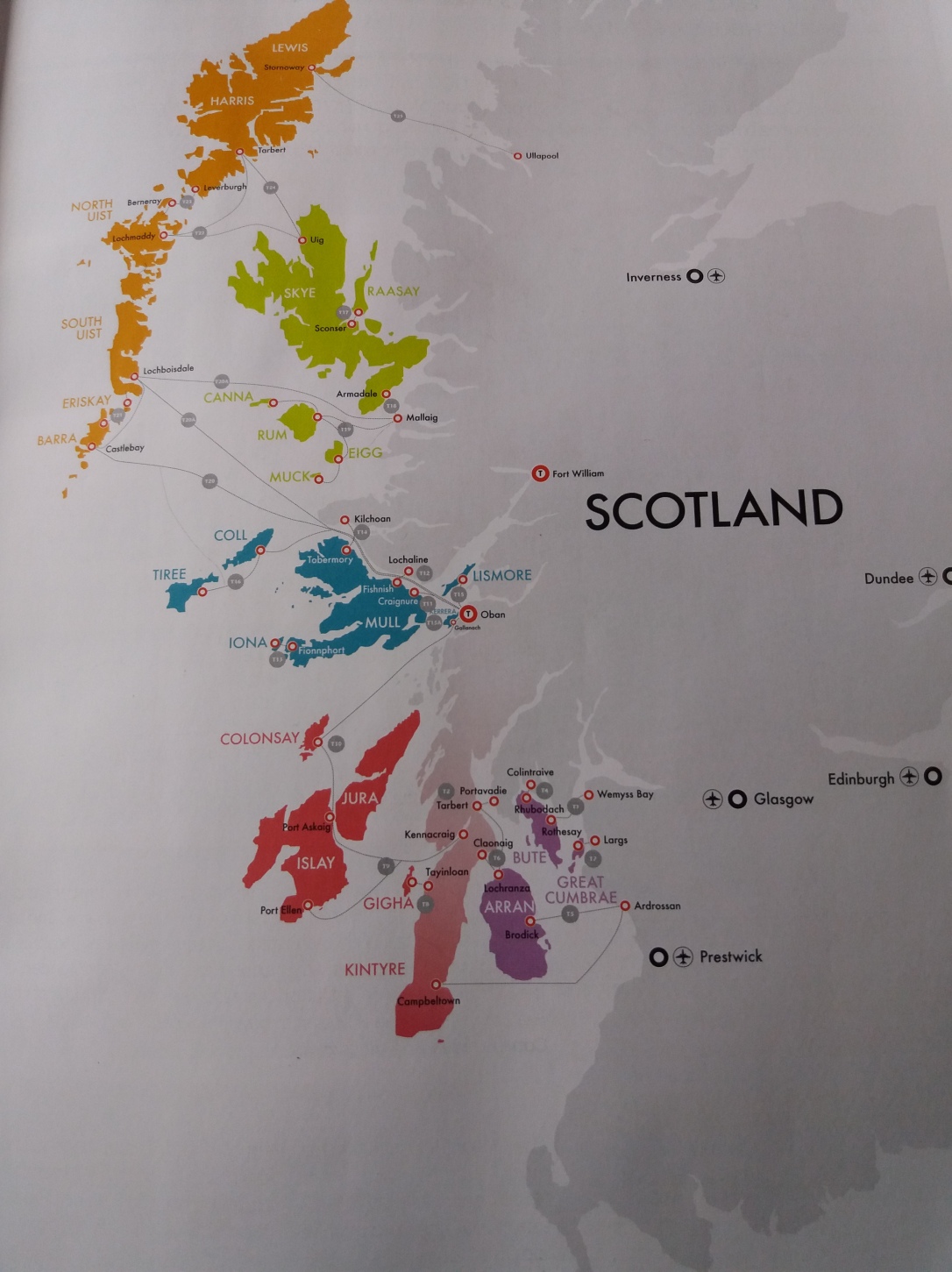
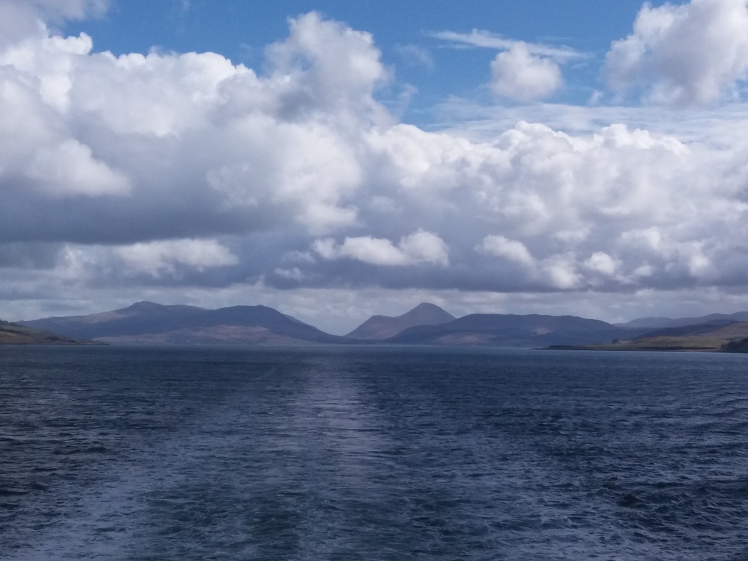
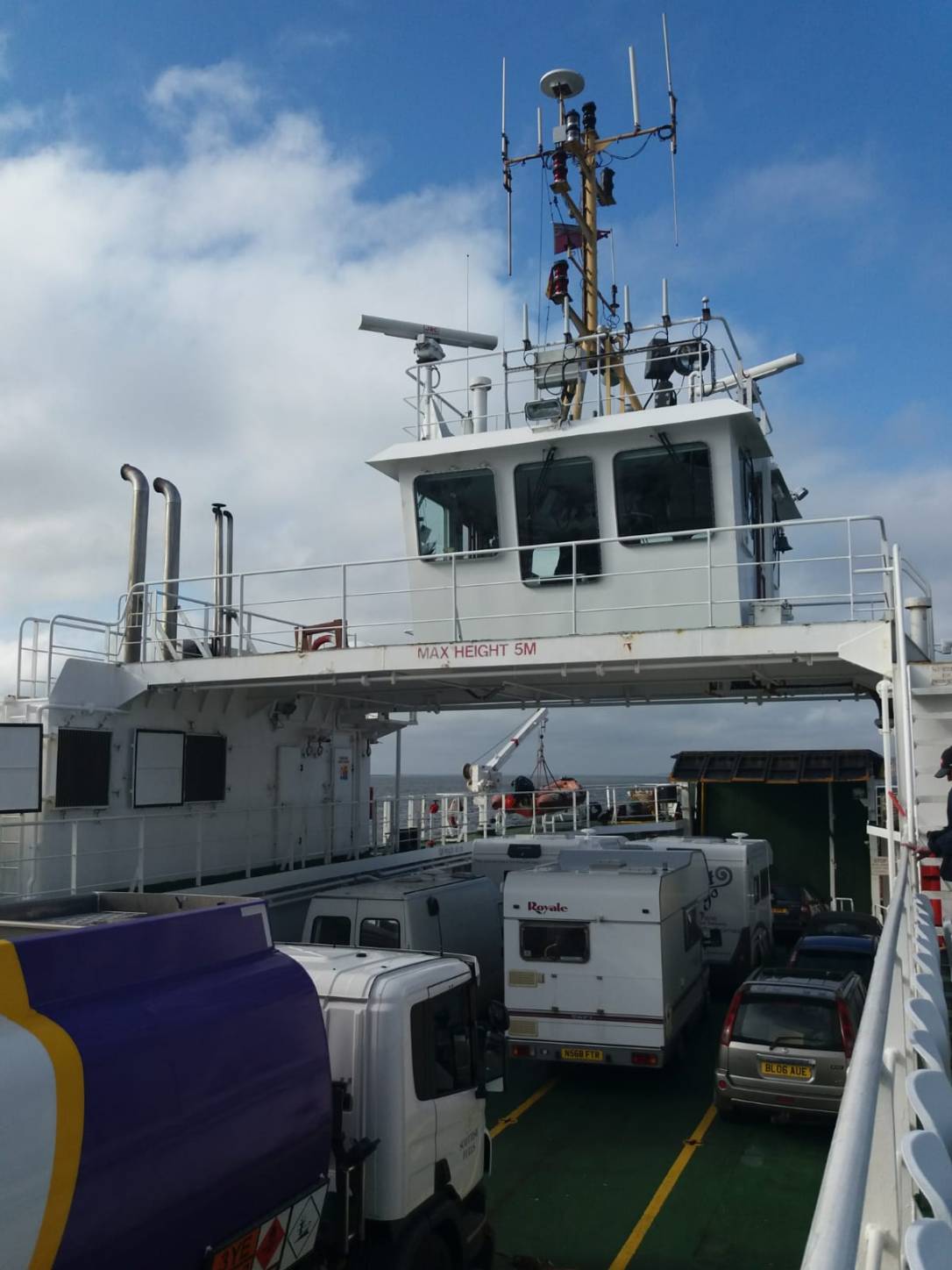
The Outer Hebrides islands (the orange islands in the handy map above) are the furthest west we could go except for the tiny island of St Kilda, another 40 miles out to sea, which as a protected UNESCO world heritage site is only open to sight-seeing (read fee-paying) day trippers on structured guided tours and unfortunatly not big white vans. We decided to start at the bottom of the islands and work our way up. The ferry to Barra, the 2nd southernmost inhabited island in the long chain, departs daily at 1:30 from the little terminal town of Oban. We managed to find a fantastic spot to wait for the night preceeding the crossing, just outside Oban near Ganavan Bay, a lovely pebbled stretch of the Scottish coast and the evening was warm enough to open the back doors and watch the sun sink down behind the isles of Lismore and Mull in its usual spectacular form.

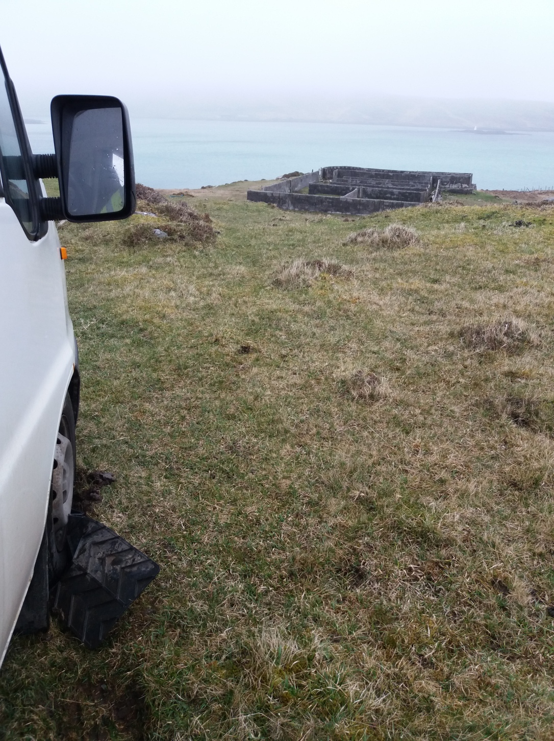
The Oban to Barra crossing takes a long slow route through the sound of Mull, providing plenty of beautiful scenes along the way. All around the boat, friendly locals stood at every window talking to us and pointing out places of note along the way that are not on our map, a large but secret-looking island fortification in one direction, a ruined castle on an eroded crag in another. After we passed by Ardnamurchan Point, the most western place on the mainland, Scotland proper faded into the blue distance behind us and the boat opened up its engines. The 5 hour journey was a little rough on my delicate insides so we ate a huge lunch of Van Surprise Sandwiches (any combo of leftovers between bread) and spent a lot of the sailing outside, admiring the view and using the many maps we collected from the terminal to name each little island as we cruised past, the trio of Small Isles, Eigg, Muck and Rum and past little Canna, stuck out like a long thin finger, pointing us on our way further west. Down the steel steps a deck below us a young man produced a violin from its case and his long sorrowful notes floated up to us, carried on the wind and out to sea.
Doing a little light reading on the journey we noticed the ‘brochure’ was in fact the ferry companies seasonal timetable. No wonder all the facilities looked so fantastic, they were trying hard to sell them to us and good for the folks in the marketing department, it worked 🤣 When you board the ferry at Oban you won’t be the only campervan in the queue and we certainly weren’t, these islands are well known to seasoned campers, vanners and motorhomers alike for the scenery, ease of wild camping and the facilities provided, most of which are open 24 hours and run on an honesty box system. We chatted with some campers and soon learned we would see these same friendly people again and again in our island travels, in ferry ports queues, on vast otherwise empty beaches, passing each other slowly on the narrow roads and visiting the same sites. Most were staying between 1-4 days and had already booked their boat onwards to the next island of Eriskay.
The first sight that greets the ferry is the magical Kisimul Castle, rising out of the sea in the aptly named Castlebay harbour like something from a Disney fairytale. The stronghold of the Clan MacNeil since around the 1050s, Kisimul is one of the oldest castles in Europe and has never fallen to any enemy despite repeated attempts over the years. It definitely is the most scenic castle we’ve ever seen, the day we sailed by it was floating in the calm harbour water under a blue and pink sky. In the distance behind the castle we saw the thin strips of beach on Uidh island across the sound shining over at us, so bright and white that at first I thought them faraway chalk cliffs but no, that is what a beach looks like out here in the Outer Hebrides.

We first drove right around the whole island in abject amazement, struggling to cope with the vivid scenery. Every turn in the road hid another spectacular sight and we must have stopped and gasped a hundred times, Barra looks just like some strange hybrid of Scottish and Irish land inexplicably floating in Caribbean waters. It’s also full of birds, we saw clusters of oyster catchers sticking their long orange beaks into the sand, a pair of rare lapwings wearing their funny black feathery caps, plump well-fed seagulls circled above and many auks, strange little puffin-looking things that took flight from the grass as we drove past. Barra has puffins too, and seals, terns, dolphins, porpoises and otters. The first beach we pulled up at was almost unbelievable. The evening mist was rolling off the hills, the island is flat with just one low peak, and we watched it spill out onto the turquoise water, standing speechless, blinded by the spotless silver sands.
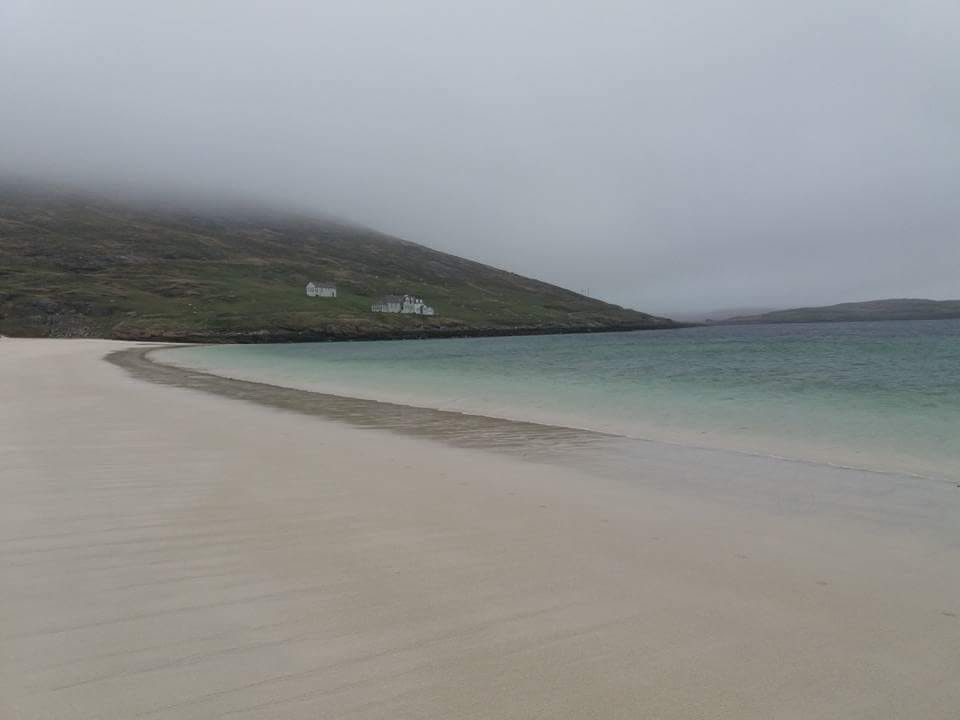
Amazing scenes, and this is the west of Scotland? You can see why the island is nicknamed Barradise! The beaches just got longer and more and more beautiful as we drove south. We took note of every sign, every crossroad and landmark and plotted the island mentally. A little causeway made of stone blasted from the concave bowl in the opposite hillside joins Barra to Vatersay Island, parting the impossibly blue waters narrowly to let us through. Vatersay is much smaller with only 90 residents, here the strands go on forever and facing the sea the high grassy dunes seen all along this side of the islands reach even further heights, their spiky tops disappearing into the misty cloud.

We could sleep that night anywhere we liked, where silver slivers of sand meet the turquoise waves or overlooking the craggy islands northern end or on the little streets of the quiet town of Castlebay or anywhere inbetween. All the campers we disembarked with had already marked their wild camp territories and dotted along the western coast vans of all sizes turned their windows towards the sunset and settled down for the evening. After a couple of false stops as we became aware of the islands extremely poor internet signal, and with both of us anxious to get online however briefly, Dixie rolled back into town and parked right opposite the floating castle where we had full connectivity and time to collect our thoughts and loosely plan our time on the island.

Standing on Barra that first morning we could have been on Ireland’s West Coast, County Mayo to be a little more precise; the very same rugged landscape, the bleak gorsey hills and rough fields, waterlogged even out of season and the acres and acres of sandy, meadowy plains full of wildlife and wildflowers. We came to learn this type of land is a natural phenomena called machair, formed by beach debris of sand, shells and stone fragments driven back inland by the wind, making fantastic grazing pastures and yes, found only here in the Outer Hebrides and the West of Ireland, County Mayo to be more precise again. After the first sign at the port proclaimed our “Failte” to the island in Gallic and below in English, and most other signs around were decipherable from Gaelige, we remarked on the many similarities between theirs and our Gaelige and we talked again about relearning to speak our real language, conversationally at least. Its not like we don’t have the time now, and each other to practise with. The local language only adds to the sense of tight knit community we felt here, the honesty box is seen all over these islands from the youth hostels showering room to fresh free range eggs and local produce left unattended in cute display boxes shaped like hen houses at the gates of many farms we passed.

Big brown and white cows grazed on the slopes of the high dunes and they took it in turns to stop pulling up the grass long enough to crane their thick two tone necks and watch us pass but really its the sheep who own this island, they maurade around in baying gangs and sit where they please and should that be one of Barras few roads, you can expect blank unconcerned deep-eyed sheep stares, sometimes they simply won’t move, even with large vehicles coming right towards them. We heard there is a standing stone on the island, a small one with a vague and cloudy backstory but definitely worth a visit and we looked around the area loosely labelled on the map but saw no trace. Instead we saw a landscape again jarringly like the west of Ireland, barren and brown, mostly treeless and stubby but surrounded on all sides by an amazing green and blue sea. We walked each beach we met, length and breadth and saw the machair in various stages of growth, transforming from sand to soil in front of our eyes. Being offline temporarily is very good for your mind but Google could have pointed us to the hiding stone in an instant.

We stayed on Vatersay that night, on the banks of an inlet called Caolas Bharatsaigh, caolas means strait, just like our Irish word chaolais. In the morning we opened the back doors and stayed in bed until after noon, watching little black otters playing together in the water outside. The weather was warm and around 2pm a thick grey mist began to seep down from somewhere and thereafter hung around all day, although grey and gloomy at times it never truly looked like rain. The nearby tiny isle of Tiree, one of the Inner Hebrides, experiences some of the lowest levels of rainfall in all of Scotland, it lies so flat and so close to the sea that it fools the clouds into thinking its not even there and they pass on by.
Vatersay Island has a few sites of interest dotted along its rugged coastline, but none more interesting to us than the black stone memorial standing on the hill near beach. Steps lead down off the road (and the very flat carpark) to a bench, there a black plaque names the victims and survivors of the light plane that wrecked here in 1944 during an RAF training flight. Poignant enough to stand at any accident spot, to read the inscriptions and reflect for a moment, but much stranger here, below this memorial sits the mangled wreckage of the plane itself, broken in large bent but recognisable pieces and resting all that time among the gorse on the rocky hill.
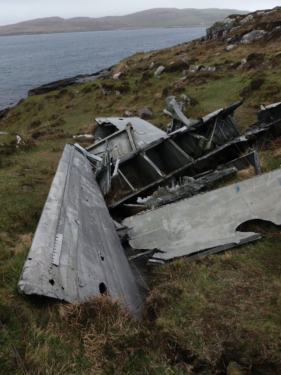
We saw the blue siding, stamped with fading parts numbers, the bent fuselage, the hallow tin wings. Someone had placed a couple of pink cloth poppy wreaths inside the remains of the cabin, dirty now, the flowers weather wilted and sad. It’s hard to know what to say about walking through this site and its quite hard to fathom how the wreckage is still in situ but time has stood still since 1944 in this spot. An eerie, thought provoking place.

That night we had a couple of drinks in the Castlebay Hotel and it was almost like being transported back to any bar in rural Ireland in the 1990s, the same decor, atmosphere and even the same farm-and-Guinness smell and onstage a local trio belted out the famous Irish tunes; Thin Lizzy, Van Morrison, Christy Moore and all kinds of loud popular Celtic rock. The place was hopping with people for an island of so few (1,184 residents) and after 10pm the crowd around the bar was growing fierce thick altogether and soon everyone was wishing aloud that they were on the N17 along with The Saw Doctors… We slipped out quietly to the next and only other bar in Barra, and that was so busy with the other half of the islands population we could barely breathe nevermind get a seat or a drink for all the pandemonium. Two curly redheaded musicians were rousing the crowd with enthusiastic singing and fiddling and all around sweating, red-faced patrons from all corners of the isle necked Guinness and shots of local whiskey and locals and tourists alike banged their hands together and stamped their feet in beat with the fiddle and the smell of hops and farm and turf fires and whooping and hollering and the warmth of so many other bodies crowded into the small room and again, we were thrown back in time, and back across the waves of the Atlantic Ocean, back to our island, Ireland.
Now, we at The Backwards Van are open to any form of entertainment we can get our hands on, so long as it is free, so when we learned that Barra Airport was ranked #2 Most Scenic Airports to land a plane IN THE WORLD (after Irelands own stunning Donegal Airport of course) by the pilots themselves, we checked the scheduled arrivals, donned our anoracks and took Dixie to visit the famous runway. Firstly, the airport is unsurprisingly small and absolutely adorable, the baggage reclaim belt ends at a bus shelter outside the building.

It was a little misty for plane spotting when we first arrived so we brewed a pot of coffee and waited for the plane, one of three daily flights from Glasgow airport, to come into sight from between the low clouds and land on the sand. The roads of Barra are mostly deserted and other than the odd taxi or airport pickup nobody passed us as we sat on Dixies step, watching the skies and wishing we owned a pair of binoculars between us. The runway is one huge expanse of sand!
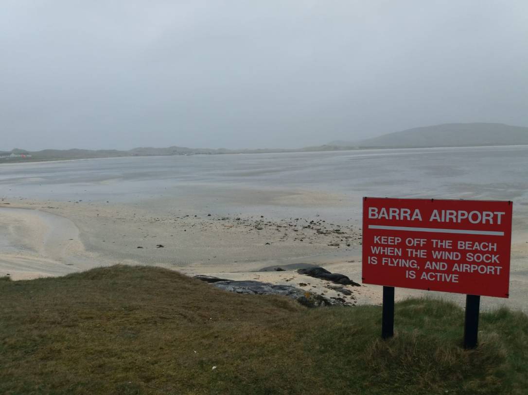
We heard the 4:30pm from Glasgow long before we saw it peeking out from the fog as it circled above the airport twice through the clouds before skillfully and smoothly touching down on the sand and coming to a stop with minimal fuss. The passengers disembarked, a big tractor picked up the luggage and we sat drinking our coffee while the plane was flipped, new passengers and luggage installed and with a mighty whoosh up she went again, this time ascending right over our heads! Check the link to Facebook for our video, incredible. An airport absolutely worth visiting!
https://m.facebook.com/story.php?story_fbid=987037561451321&id=851906444964434
We drove all over the island leisurely for the next few days, revisiting each of the sites and beauty spots, redriving every road, rephotographing every little thing. Everytime we got to the northern part of Barra we laughed and remembered we still hadn’t found (and recorded offline) the precise coordinates of the elusive standing stone. Vatersay community centre provides fantastic facilities for vanners and we visited frequently over the days to wash our dishes and our selves, there I met one of the Vatersay Boys, a local trad-rock band who told me all about their tours of Ireland. Most evenings we returned to the spot in town near the beautiful floating castle and the comforts of internet connectivity, staying in town was fun, often at night we were treated to private conversations held outside, in a strange rural hybrid language mangled further by the drink, and those mornings we woke late to the sight of mysterious, romantic Kisimul Castle in the bay. One evening as we finished the lovely Herring Trail walk along the seashore a friendly gentleman invited us in to the hostel for a drink and we spent a few warm hours in the company of other travellers, sharing stories and laughs. One whole day and night we huddled in Dixie while gale force winds seemed to rip and pull the island apart yet in the morning no damage was visible, the sun shone brightly and it was business as usual. Barra Island is a feeling, a frame of mind, a weird little place that could so easily be straight out of Father Ted in its Irishness but no, the people here are real, friendly and approachable with the same quick wit and they’re so very… Celtic, just like us. Our faces were sore from laughing and smiling and our cheeks stung red by the wind. By now we had waved goodbye one by one to our fellow ferry campers or should I say we noticed their absense by the vacant spaces they left on the landscape but every evening at 6:30pm the CalMac ferry cruised back into town and another set rolled out, vans of all shapes and sizes dispersing quickly to the best spots for a few days of peace and quiet. Barra is incredible, laid back, weathery, some how both barren and richly fertile at the same time, the beaches are astounding and the wildlife different and everywhere we looked.
I have mentioned previously my rather predictable (and annoying, even to me!) reluctance to leave something good once I’ve found it, stubbornness being a trait my mother would tell you I was most probably born with and poor William is learning all about these things as we go but maybe that is why it made me laugh at first, when we pulled suddenly off the road to investigate a brick sheep maze, to see Dixie dig her rubber heels deep into the mossy, deceptively soggy machair, and when we were finished oohing and aahing at the view (Barra-bados is another apt moniker) and climbed back on board, she spun her wheels around merrily in the muck but refused to move.
It must have been fate telling us to stay on Barra forever, I thought, we will live right here now, on this spot but alas, within minutes a kind motorhoming couple called Tim and Jane stopped to lend four hands and, when brute strength didn’t move the stubborn Ducato, they let us borrow their heavy duty grip mats. I stood around getting some serious campervan envy (its a real thing, their van has A GARAGE) while Dixie took the mats under her wheel and effortlessly buried them even further into the muckhole. Tim and Jane offered to take one of us into town to get help but I said no thanks, I’ve seen that horror movie before, the main characters separating to “find help” usually goes badly, especially for the girl. They looked at me a bit funny, we all agreed they could help no further and off they went, sans embedded grip mats, leaving us their best wishes and their best hitching rope to be returned if and when we ever escaped our quandry.

Being stuck in a campervan sinking slowly in machair isn’t the worst thing in the world but with Dixie facing arseways off the road we were not at an angle safe enough to relax until rescue. Luckily, Mr Local came along with his reliable white transit van, his thick accent and, as it soon transpired, his relatives in County Mayo, and with a little persuasion Dixie just had to learn to let go of the grip mats, let go of the mossy machair and get dragged back to the reality of the road.

Tim and Jane were exactly where they said they would be and the rope and cleaned up mats were returned with our many thanks. We knew the time had come to leave but saying goodbye to Barra without finding the standing stone was bad enough, we couldn’t possibly go without setting foot in that bewitching little castle. After breakfast on our ‘supposed’ last day in Barra we boarded the little dingy for the 2 minute ride across the water.
Kisimul Castle is just as enchanting on the inside and we walked the little courtyard and bent to enter the low doors surrounding, Up some creaky wooden stairs we poked our heads out the embrasure holes, played Spot-The-Dixie on the shore and weaved in and out of the ancient rooms. In the chapel, the headstone of a MacNeil chief, an enormous inscribed slab lies flat to the ground and plaques commemorate all who have patroned and supported the restoration of the castle, which is now leased to the Historic Environment Scotland for the next 1,000 years in return for £1 and a bottle of whisky, a very Scottish contract indeed. Some of the rooms are grand with high roof beams and the whole castle is very well maintained given its age. In a corridor in the highest tower we found a toilet with a wonderful view of Castlebay from the window in front of the throne, on high alert for attack during every waking moment. There was a hole with a grill to poop into and the waste falls down to the sea, the ultimate compost situation. Odd to be examining a medieval castle toilet but it worked then just like it would work now.

The castle has a little courtyard where plants were grown for food and the tiny island even has a deep fresh water well. Imagine life for generations of the clan MacNeil out here in the harbour, although the sun was shining during our visit the castle must be bleak in harsh winter and surely terrifying during Barras regular gales.
The 3:45pm boat to the mainland left without us, they did offer to come back but we waved them on their way and gladly went in for another look around.

Killing time until the 4:20pm, I asked the lady in the little gift shop where we had purchased our tickets if she knew how to get to the standing stone we had read about. The boat man, on his break between 2 minute trips over and back all day, turned to me and said “Its only a wee ‘un, but its just after the junction by Celinas house.” The lady agreed emphatically, she had not seen the stone herself she said (“believe it or not, in all my years living here!”) but she knows the junction and she knows Celinas house. Now, thats not much help to a stranger to the island, unless Celinas house is a bar or a hotel but surely we would have noticed that during the preceeding week. An awkward silence followed while we waited expectantly for a little further direction but none was forth coming, just some friendly nodding and smiling, so we thanked them both anyway and got on the next little boat off Kisimul, none the wiser about the stone.

By then the last ferry to neighbouring Eriskay had long sailed so we took another drive around the island to try to find the junction. The evening was still young and we tootled along the narrow roads, suddenly a long shiny otter appeared in front of us, scampering acrossing the road between one grassy marram dune and another. He must’ve been about 3ft long from his wet nose to his sleek, pointy tail and he lept up into the grass between the legs of some sheep loitering on the verge, causing a little panic, a brief and fluffy kerfuffle and some baying and scattering. I couldn’t get a photo fast enough but much to the sheeps annoyance the otter stayed up on the verge, weaving amongst the ruminants legs and suspiciously watching us pass with his beady black eyes and long lashes. A minute or two later William said he just knew, and pulled Dixie up on the side of a road we had taken plenty of times before, in both directions, it was just passed a junction, just near a house… could it be Celinas house?

Yes! The Standing Stone of Borve is small alright but its not alone, a chambered cairn sits in the same field, just opposite Celinas house. On nearby Vatersay an Iron Age broch was discovered, a drystone hallow-walled structure unique to Scotland, and in the 1990s a 4,500 year old beaker was unearthed here. People have lived and worked these wild, remote islands since Neolithic times. The above photo I had to filter to publish, the mist was so thick, but you can clearly see at the base of the stone the machair, the sand directly below the thin green layer of grass, moss, shamrock and clover. After examination of the stone and its surroundings I wanted to find Celina too, and ask her all about her life on Barra Island in her little house by the junction, was I still stalling?
That night we slept by the port on the northern side of the island in Ad Mhor, a vain attempt to make leaving Barra easier. It didn’t work. We slept through the first 2 ferry foghorns, missed the 3rd boat by chatting with a gaggle of cyclists and playing the ukelele instead of boarding and I was visibly disappointed when the final boat of the day had plenty of room for everyone in the queue and the CalMac employee ushered us onboard. Barra Island is a mood, peaceful, friendly, wild and remote, a place we won’t soon forget. A little bit of Ireland out on the Western Isles of Scotland but more than that, remote, romantic, inspiring, strange and beautiful, an ancient little community all the way out here in the wild Atlantic Ocean.
Barradise lost? Barradise found, for us at least. This lovely little island jumps to the top of all previously compiled lists of ‘most beautiful’ this and ‘most interesting’ that after our 9 months on the road, a place we did not want to leave, ever really, and although we know it’s not a competition, if it was? Barra is winning 😉

Lovely! Thanks for the memories! I stayed on Lismore for 6 blocks of 2 weeks winter of 06/07
CalMac ferries was a wonderful and essential part of the whole experience! Would live to visit Barra one day!
Happy Dixie Days!
Kx
LikeLike
Thanks Liz, these islands are so inspirational, I’m sure Malachy could wrote out here and you could certainly paint, the landscapes and weather are perfect for us!!
LikeLike
Some really great pictures with amazing views 🙂
LikeLike
I really enjoyed your write up about Barra and Vatersay, it bought back memories of my cycling trip there a while ago.
LikeLike
Great writing – almost feels as if I have been there – but didn’t even know about these Islands 🙂
LikeLike